Myth, legend and fact mix together for the tale of Piri Reis. His world maps have caused controversy since their discovery back in 1929. They have been the topic of debate for amateurs, historians and researchers, and the debate is still in full swing till now; space aliens and ancient extinct civilisations are a normal occurrence in these debates!
“The sons of Gallipoli spent their lives in the sea like crocodiles, the boats their beds, the sea and the ships lulling them to sleep day and night.” Ibn Kamal, Ottoman historian.
Hadji Ahmed Muhiddin Piri was a Muslim Turk; an Ottoman Kapudan-i Derya (Captain of the Sea), geographer and cartographer; born sometime between 1465 and 1470 CE (869 and 875 AH) in Gallipoli on the Aegean coast of the Ottoman Empire. Like most children in his hometown, he was schooled at home until the age of 12 where he was handed over to his uncle, none other than the famous Kemal Reis Admiral of the Ottoman Navy (known in Europe as Camali and Camalicchio), who would become his mentor until the time of his (Kemal’s) death.
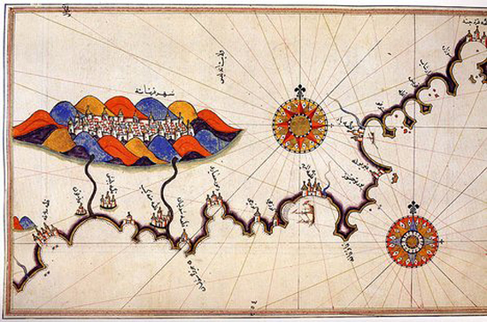
Map of Granada by Piri Reis, Kitab-ı Bahriye 1521-1525.
Under his uncle’s mentorship, this observant eager boy grew into a master navigator and keen warrior; he took part in many naval wars of the Ottoman Empire against Spain, the Republic of Genoa and the Republic of Venice, including the First Battle of Lepanto (Battle of Zonchio) in 1499 and Second Battle of Lepanto (Battle of Modon) in 1500. In the late 1400s, the Muslims of Grenada, the last Muslim stronghold in Spain, had asked for help from the Ottomans, Egyptians, and Tunisians. Some of his earlier missions with Kemal Reis and his crew were to ferry oppressed Jews and Muslims from the Spanish cities and relocate them to the Ottoman Empire that welcomed them and gave them a new home. They were the final remnants of the surviving Muslims and Jews who had to suffer inhuman treatments since the Spanish Inquisition of 1492 and brought them to Constantinople (Istanbul).
Following the death of his uncle, he returned to Gallipoli in 1511 to work on his first world map and an earlier version of his Book of Navigation.
By 1516, he was again at sea as a ship’s captain in the Ottoman fleet. He took part in the 1516–17 Ottoman conquest of Egypt, he served under the command of Cafer Ağa Pasha (Arabic: Ja’afar Bey). Piri took a part of the fleet up the Nile from Alexandria to Cairo, charted the area, and penned detailed observations of the region. The conquest of Egypt was personally led by the Ottoman Sultan Selim I and his Grand Vizier Hadim Sinan Pasha.
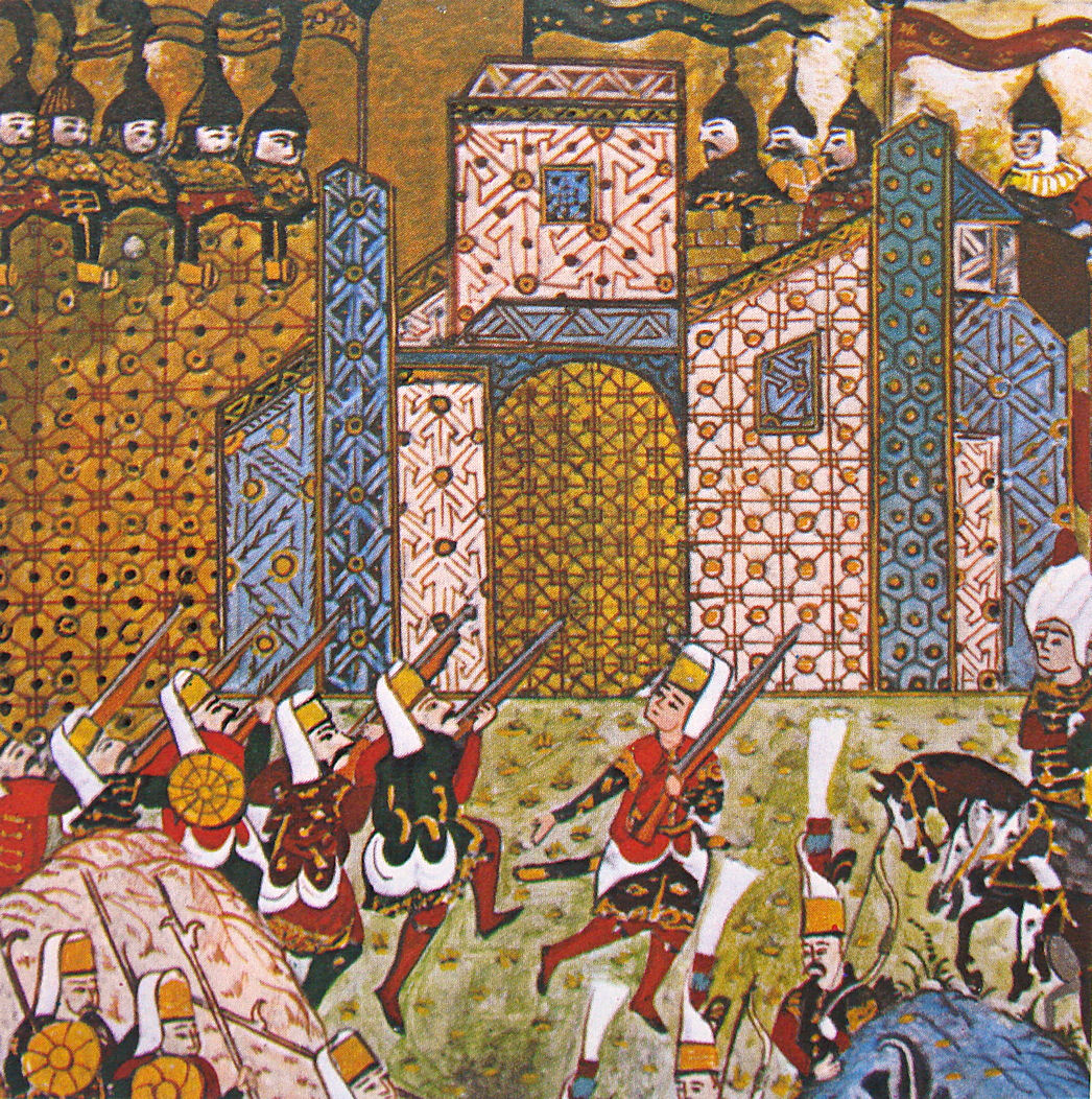
Gun-wielding Ottoman Janissaries and defending Knights of Saint John at the Siege of Rhodes, from an Ottoman manuscript.
From one conflict to the next, Piri Reis took part in almost every naval campaign that would take place in the Mediterranean, Indian Ocean, and the Arabian Gulf. In 1522 he participated in the Siege of Rhodes against the Knights of St. John, which ended with the island’s surrender to the Ottomans on 25 December 1522 and the permanent departure of the Knights from Rhodes on 1 January 1523 who relocated first, briefly, to Sicily and later, permanently, to Malta. In 1524 he captained the ship that took the Ottoman Grand Vizier Pargalı İbrahim Pasha to Egypt.
By 1547 Piri had risen to the rank of Reis ‘Admiral’ as the Commander of the Ottoman Fleet in the Indian Ocean and Admiral of the Fleet in Egypt, headquartered in Suez. From his base in Suez, he launched several campaigns against the Portuguese, who had dominated the Muslim coasts and the Indian Ocean by then. He recaptured the port city of Aden from the Portuguese in 1548 and restored it to Muslim rule, then Muscat followed in 1552, which Portugal had occupied since 1507, and the strategically important island of Kish.
Once he secured the Southern Arabian coasts, he turned his sights further to the east, capturing the island of Hormuz in the Strait of Hormuz, at the entrance of the Arabian Gulf, and then occupied the Qatar peninsula and the island of Bahrain effectively depriving the Portuguese of suitable bases on the Arabian coast.
An old man approaching the age of 90, he fought one last battle against the Portuguese in Basra, sadly it was a battle he did not win, and he retreated with several of his ships to Egypt. However, his life would not end while fighting or on his bed as an old man, it would end due to jealousy and the machinations of the Ottoman Wali of Basra, Kubad Pasha, and was executed in Egypt around 1554.
His legacy, however, remains.
Kitab-ı Bahriye (Book of Navigation): 1521 and 1525
After the fall of Rhodes, Piri Reis was appointed as an Advisor to the Ottoman Grand Vizier Pargalı İbrahim Pashais by royal decree. After learning of Kitab-ı Bahriye and reviewing it, Ibrahim Pasha encouraged Piri Reis to turn it into a proper book and update the world map included in it. The book was then revised with additional information and better-crafted charts and then presented to the Sultan Suleiman the Magnificent as a gift. The revised edition had a total of 434 pages containing 290 maps.
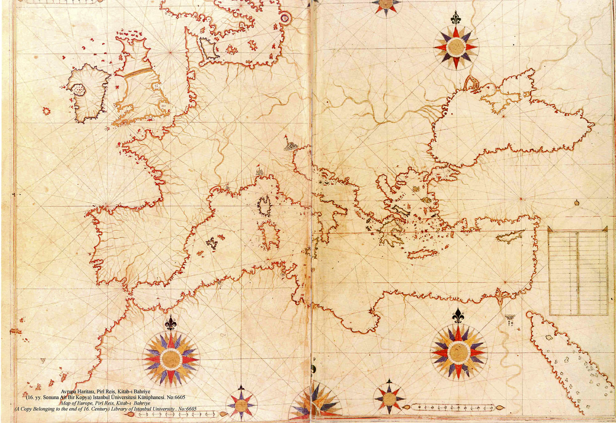
Map of Europe, the Near East and North Africa in the Kitab-ı Bahriye (Book of Navigation) of Piri Reis.
One of the most famous pre-modern books of navigation, it includes not only maps, it also contains detailed information on the major ports, bays, gulfs, capes, peninsulas, islands, straits and ideal shelters of the Mediterranean Sea, as well as techniques of navigation and navigation-related information on astronomy, together with information about the local people of each country and city and the curious aspects of their culture.
The book is split into two main sections, the first is dedicated to information about the types of storms; techniques of using a compass; portolan charts with detailed information on ports and coastlines; methods of finding direction using the stars; and characteristics of the major oceans and the lands around them.
The second section is entirely composed of portolan charts and cruise guides. Each topic contains the map of an island or coastline. It starts with the description of the Dardanelles Strait and continues with the islands and coastlines of the Aegean Sea, Ionian Sea, Adriatic Sea, Tyrrhenian Sea, Ligurian Sea, the French Riviera, the Balearic Islands, the coasts of Spain, the Strait of Gibraltar, the Canary Islands, the coasts of North Africa, Egypt and the River Nile, the Levant and the coastline of Anatolia. The second section also includes descriptions and drawings of the famous monuments and buildings in every city, as well as biographic information about Piri Reis who also explains the reasons why he preferred to collect these charts in a book instead of drawing a single map, which would not be able to contain so much information and detail. Source.
The Piri Reis map controversy
A lot of controversy surrounds the world map of 1513 by Piri Reis, it is very hard for some people to acknowledge the feats of some men and women in history, so to put their minds at ease they resort to tales of space invaders and imaginary pre-classical civilisations instead of admitting that what they see before them was the result of hard work and perseverance.
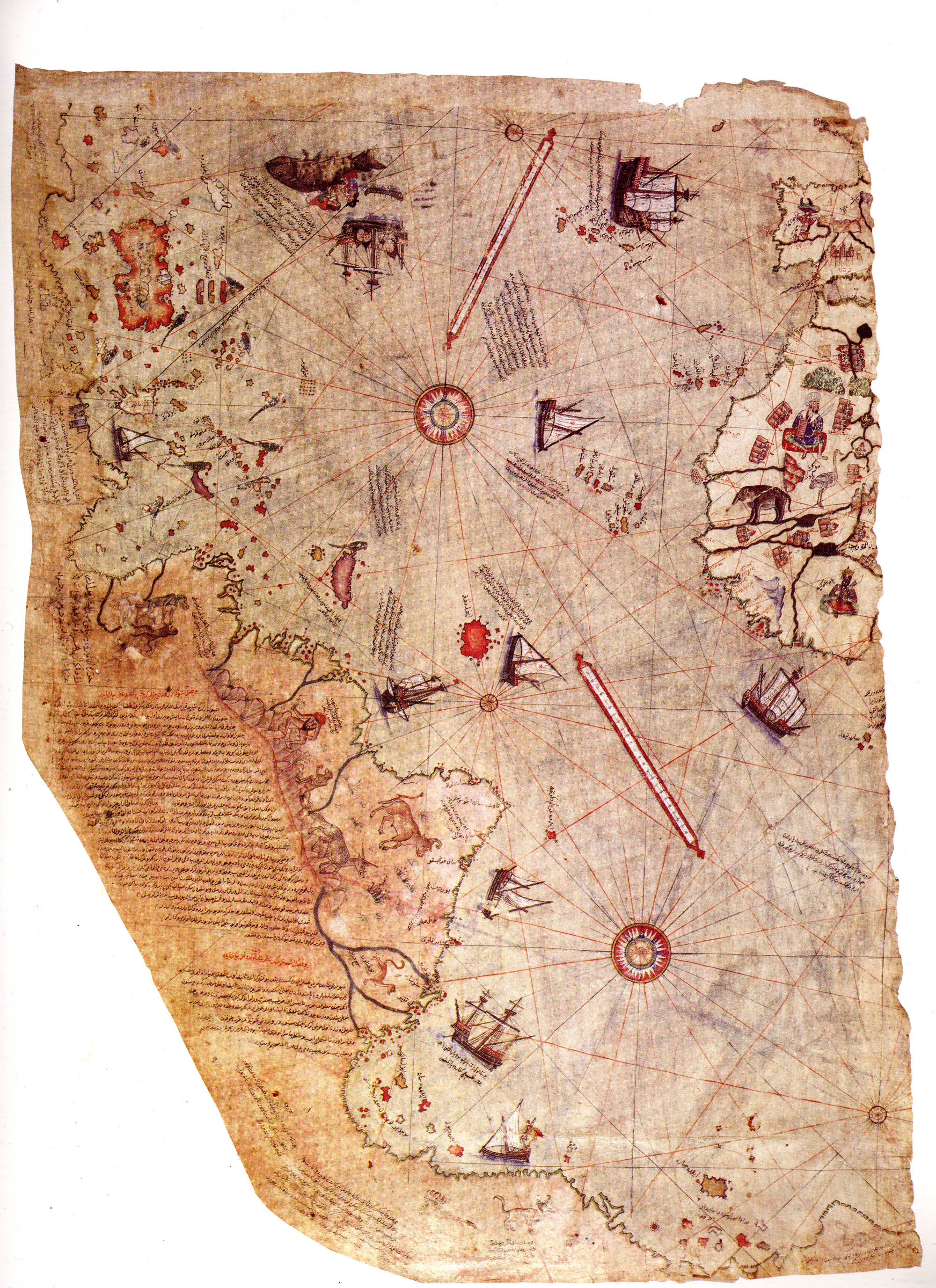
Surviving fragment of the first World Map of Ottoman Admiral Piri Reis drawn in 1513. Only half of the original map survives and is held at the Topkapi Museum in Istanbul.
Piri Reis laid down his sources for the map in the side notes; it was drawn using 2o maps, including Portuguese, Spanish, Arab, and Greek maps. It was a first class piece of naval intelligence constructed wholly from second hand sources and containing up-to-the-minute details derived from enemy maps, many of which would have been tightly-guarded secrets. Source.
It was the accomplishment of gifted admiral and good intelligence analyst and not a hand-me-down from little green men from outer space.
For more information about Piri Reis please visit:
http://en.wikipedia.org/wiki/Piri_Reis
http://en.wikipedia.org/wiki/Piri_Reis_map
http://www.fustat.com/geog/piri.shtml (Arabic)
http://www.fustat.com/geog/piri2.shtml (Arabic)
Islam Story: Piri Reis Map and the Discovery of America (Arabic)


Trackbacks for this post